Friday morning we decided to go on a hike. I couldn’t really decide if we should got to Bull Creek or Barton Creek. I knew that both of them were roughly near Hwy 360 south of 183 here in Austin. I figured we’d drive, see a sign, and voila! we’d have our hike. I’d remembered seeing a pullout or two that I thought were trailheads. So kids in the car, Wesley talking his head, Jillian screaming hers off, we drove and drove and drove. A lot farther than I thought and much farther than Amber was expecting. It got a little tense in the car, as it can when one or more of the kids is screaming. I just knew I had seen an area for access to Bull Creek along the road during one of my many trips to or from Jeff and Chris’.
Eventually we realized we had gone too far and did a U-turn. A fortunate thing about Texas highways and freeways is that they have many (I mean all over the place) U-turn locations. These are paved and often well marked, designed just for that purpose. A ways back we had seen a sign for the Wild Basin Wilderness Preserve. So we drove back, parked, and started to get ready. Other folks pulled in well after us, hopped out and were probably well down the trail before we even left the car. We had to feed Jillian, change diapers, get kids in packs, put on hats, make sure we had water and more. I’d say it took us 15 minutes or so just to get away from the car.
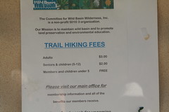
Now, I had no idea what to expect. When we first pulled in we weren’t even sure that there were trails we could hike on. Wesley and I did a bit of reconnaissance and found the trailhead board. The fact that they were asking $3 for adults and 2$ per child for use of the trails seemed like a bad omen to me. It is just so backwards down here sometimes. In Washington I’d have expected (depending on the managing group) to pay for parking at the trailhead. Maybe $5 per car. But I’d never expect to pay to actually hike on the trail. I guess the thinking in Washington is that you want to encourage hiking and discourage as many vehicles as possible. What is the thinking in Texas? Beats me.
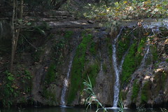
We grabbed a flyer from the edge of the donation box and started down the trail. To my surprise the trail was marked with perhaps 40 markers. Each with a describing paragraph explaining the plant or geographic feature in front of you. It was quite nice especially since I am so unfamiliar with virtually all of the plants and animals in this part of the country. We hike down to the waterfall first. It isn’t big, it doesn’t have that much volume, but it was rather pretty in a quite sort of way. We hiked down a detour (causing us to miss some of the markers) on the Madrone Trail. It added a couple of miles to the otherwise very short loop. The terrain on this part of the trail kind of reminded me of hike Amber and I took a few years ago from Diablo into Ross lake. Just the general density of brush and trees was similar. There was some elevation gain here and we crossed a couple of very small creeks along the way. The wildflowers were quite gorgeous and I’ve never seen any of them before. It gave me hope that we can create a garden in our yard that will be both beautiful and require little or no watering.
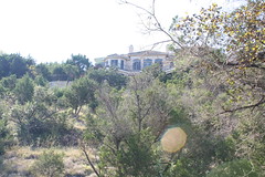
The 227 acres of the park are wedged between two large housing developments and the highway. The land covers part of what would probably be called a valley if it were larger. The land has been protected since 1974. Unfortunately you can almost always (or at least quite frequently) see the large houses at the edge of the park. I assume that the preserve itself has encouraged the development right at their borders. Who wouldn’t want that as their backyard? The houses and highway did detract at times from the overall feeling of the place. You certainly never get the “all alone” feeling you can get in the North Cascades. Still, I was able to get lost in the moment even if only for short periods.
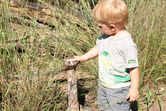
About the time we were heading back to the main loop Wesley got tired of being in the backpack. We let him out and he had a ball. He ran, he tripped, he scraped himself. But mostly we would tell him “Okay, now we need to find the letter ‘P’” and he would take off looking for the next marker. When he found it he would, without fail, get very excited and then lean his belly on it saying “sit”. I would read the description in the map, we would take a few pictures of whatever it was and then head to the next one. All in all Wesley hiked at least a mile this way, often uphill, with very little complaining and hardly any coaxing needed to keep him moving. He was quite the trooper. It was fun watching him rush over to whichever marker was next on our list. His enthusiasm is contagious.
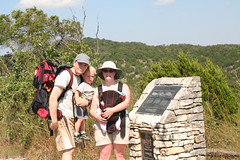
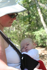
Jillian slept most of the way, waking only long enough to eat a quick meal in the Baby Bjorn (she’s still too little for the Ergo) near the letter V. Amber carried her the entire way and I’m sure she was cooking from the bodyheat. Jillian was covered up by long sleeves and her sunhat, but the rest of us were taking quite a beating by the sun which by this time had really come into its own. Near the end of the 2 1/2 hour long hike we were all getting pretty tired. We still had a number of natural stone steps to climb to get back to the car. We stopped at the overlook to take this picture. There were a number of bronze informational plaques that Wesley called “TVs”. Then a few more feet and we were at the gift shop/information center. Not much here except some water ($1.00/bottle) and a few books that look like they have been there for a long time.
All and all I think we’ll be back. We missed some of the letters and a bunch of numbers on the tour due to our hike down the Madrone trail. It seems from reading the sheet that springtime is really peak for flowers so we’ll certainly be back then. It was nice that no dogs or bikes were allowed. We never worried about letting Wesley walk down the trail. I’ve heard that at some of the parks you’ve got to be extremely careful that you and/or your kids don’t get mowed down by speeding bikes. I’d thought about membership to the organization as one of our monthly donations, but their website offers no information at all. They say to call. What info do they need to tell me about membership that can only be given over the phone?

Tags: Amber, Austin, hiking, Jillian, Wesley, Wild Basin Wilderness Preserve

UPDATE 2007-10-04: The trip is on hold. While writing this post I started to look at just how long a trip this is. And frankly, 1000 miles (roundtrip) is too far for one four hour hike. Gas alone is going to cost almost $150. So, for now we’ll probably just go hiking around Barton Creek or Bull Creek. You’ll still get pictures, they’ll just be cuter and filled with Jillian and Wesley. Plus, I’ve read that November is really the time to go see this area as the trees change color. Maybe I’ll make a weekend of it and hike Hunter Peak as well.
This Friday I plan to scale the highest point in Texas. Don’t laugh. I know what you are thinking…Texas, high point? What is it a one redneck standing on another rednecks shoulders? Actually, Guadalupe Peak is a respectable 8,749ft making it the 14th highest in a list of high points for each state. Unfortunately for me, the peak is in the far west corner of Texas just along the border with New Mexico. The mountain and surrounding area are part of Guadalupe Mountain National Park. It is one of only 4 state high points to be part of a national park. The others being Denali in Alaska, Clingman’s Dome in Tennessee and Rainier in Washington. So hopefully that means it will be nice hike.
I’ll leave Thursday evening, after the kids are asleep, and drive the 8-9 hours West to get to the park. I’ve loaded up my mp3 player with a few books on tape, plus some music. From experience I can tell you that there are parts of that area of the state that don’t have any radio stations at all. When you do get radio they are usually in Spanish or Praise Jesus. I’ll get there around midnight or so just an hour or so from New Mexico. I’ll sleep in the car with the seats down and my camping pads doubled up. It should be comfy enough and with lows in the 70s I should be plenty warm. In the morning I’ll start the hike.
The hike itself starts at the Pine Springs campground at 5,822ft. 8749-5822=2927 feet of elevation gain! The trail is about 4.25 miles each way. At less than 700ft per mile it should make a fairly easy hike. I’m expecting just a couple hours in and a couple hours out. I’m bringing the camera and should have lots of pictures to show for it.
I’ll write more and post all those pictures when I get back. That should be sometime on Friday evening or afternoon. Depending on when I get up I plan to head straight back home after the hike. I can’t wait…
A Few Links:
http://americasroof.com/tx.shtml
http://en.wikipedia.org/wiki/Guadalupe_Peak
Tags: guadalupe-peak, hiking, texas
I’m playing around with the website a lot. You may have noticed. It looks different every couple of hours and now has some ads and other widgets not to mention new stuff behind the scenes. All this madness does have a purpose. I’m toying with the idea of generating some income from blogging/content creation. To that end I’m experimenting here. Once I make a decision all the funk should disappear from this website and it will return to normal. One of the main places I’m garnering ideas is Problogger.net. They are currently celebrating a birthday.
Don’t worry. The Wesley/Jillian photos and stories will continue uninterrupted.
Now that is some title. You’ll have to admit. And I bet you’d like me to explain it right off the bat. Well, you’ll just have to wait a bit and stick with me. The title grew out of the events that unfolded and I think a proper retelling is in order.
Wesley and I were out in front of the house last Sunday taking turns drawing with chalk, looking at insects, playing with rocks, and the other kinds of things that 22 month old boys like to do with their dads. At some point Wesley decided he was done with chalk and instructed me to come over to the front door of the house and “sit!”. So I did. He proceeded to bring me rocks from around the base of the house and we oohed or aahed over them as appropriate. “Isn’t this one smooth.” “Boy! This one is sparkly.” “Look at that one. It has holes in it. It wasn’t long before Wesley was bringing me handfuls of rocks at a time and dumping them on my lap. But, even that got boring quickly and he was in search of better rocks. As they say the grass is always greener…
Seeing all the rocks in front of the kitchen window Wesley insisted we explore. He took the lead as we weaved our way between the bushes and the house. We were playing with some rocks, looking for insects, etc when I turned around and saw that Wesley was eating something. To be accurate, he was in the process of spitting that something out. I told him to spit more and to show me his mouth. This is something we do a lot as he has a habit of putting small rocks in his mouth and then crunching down on them. When the tongue came out I saw a small seed resembling the seeds of a chile, only tiny. I did a finger sweep and removed it. At this point I was looking around for what Wesley had put in his mouth and it became clear.
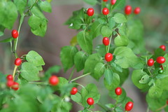
We have a small plant just in front of the kitchen window. I have no idea what it is, but it has little berries (for lack of a better word) that look like very small upside down chiles. They start out green and then turn bright red. Wesley had begun chewing on a red one, but hadn’t gotten too far. His mouth was now on fire. He was panting and doing his water sign so emphatically that I knew we had to go inside in a hurry.
Now being the kind of guy I am, I made an interesting choice. On the way in, I grabbed a berry for myself, squeezed it and touched it to my tongue. Yikes! HOT, HOT, HOT! Wesley and I proceeded to guzzle water, ice chunks and milk. I tried to get him to drink only milk, but he really wanted ice. After a few glasses of water I was feeling a little better, but still could feel the burn on my tongue. Wesley however was still unhappy.
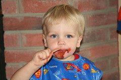
I went to the freezer and pulled out a fudgsicle. Wesley ran to the hearth (one of only three places we eat in the house: kitchen, dining room table, being the other two). He and I shared the fudgsicle. The area around his face had begun to turn red from his spit and from the way he was rubbing his hand on his mouth. One fudgsicle down and still not a happy tongue. I pulled out a second. He ate this one without sharing and by the end was looking pretty good. His mouth still had a pink ring around it, but he seemed mostly back to normal.
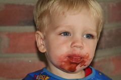
He headed back into the kitchen to look at the plant. He pointed and said hot and then he flapped his arms doing his bird sign. I questioned and Amber confirmed that they were eaten by the birds. I haven’t got a clue what those little things are. We didn’t call poison control (I know some of you are wondering) because he didn’t swallow the berry, I could see it on the ground. I don’t think he got it have chewed once before spitting it out. But I can attest to their power. Later in the afternoon I went for a run. After about 2 miles I was really sweating and my wrists were burning. Really burning, itching, hot. It was uncomfortable enough that I was dumping my water over them. I think that either I touched them or Wesley did with some spicy hot bird berry juice and the combination of sweat and rubbing from the gps and jogging stroller strap set my wrists on fire.
So there you have it the double fudgsicle spicy hot bird berry cure.